


GPS Accuracy!

Thread Starter
Join Date: Feb 2002
Location: london uk
Posts: 373
Likes: 0
Received 0 Likes
on
0 Posts
GPS Accuracy!
Whilst on a trip to Scotland over the festive period, i discovered the highest road in the UK. There was a plaque telling me i was 2053ft above MSL. Couldnt resist the temptation to check my Back up GPS which was in the glove box. See picture!
[IMG]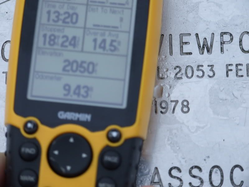 [/IMG] I think even IO540 will be impressed with that accuracy!
The road in question is appx 10km 350deg from Plockton airfield on the Applecross mountains
PG.
[IMG]
[/IMG] I think even IO540 will be impressed with that accuracy!The road in question is appx 10km 350deg from Plockton airfield on the Applecross mountains
PG.

Thread Starter
Join Date: Feb 2002
Location: london uk
Posts: 373
Likes: 0
Received 0 Likes
on
0 Posts
only a minute or two, the accuracy stated on the unit was +/- 17ft! All 12 channells were aquired at over 90%. Not bad for a �150 unit i think?
These two pics show tha plaque in full and the view to the west of the Isle of Skye. PG.
[IMG] [/IMG]
[IMG]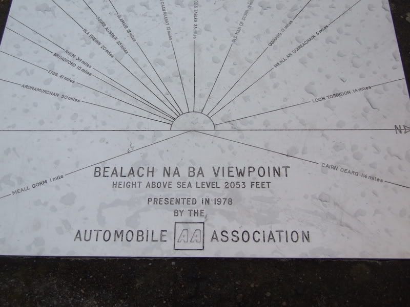 [/IMG]
These two pics show tha plaque in full and the view to the west of the Isle of Skye. PG.
[IMG]
[/IMG][IMG]
[/IMG]
Join Date: Jun 2003
Location: EuroGA.org
Posts: 13,787
Likes: 0
Received 0 Likes
on
0 Posts
I am impressed.
Normally I would expect a decent GPS to be within about 20 feet
Mind you, if that spot was surveyed in/before 1978 (as the photo suggests) it's very possible your GPS is more accurate than what they had back then.
Good pics BTW
Normally I would expect a decent GPS to be within about 20 feet
Mind you, if that spot was surveyed in/before 1978 (as the photo suggests) it's very possible your GPS is more accurate than what they had back then.
Good pics BTW
Thread Starter
Join Date: Feb 2002
Location: london uk
Posts: 373
Likes: 0
Received 0 Likes
on
0 Posts
To be honest the readout said +/-17ft and a sub meter accurcy unit would normally cost in excess of �20k. However, the reading was stable for long enough to get my camera and take the shot!
Join Date: Feb 2007
Location: Amsterdam
Posts: 4,598
Likes: 0
Received 0 Likes
on
0 Posts
There are a few misconceptions here. Not that I'm the definitive expert (so bring on the corrections) but here's a few thoughts:
- GPS, on its own, is less accurate in the vertical than in the horizontal (on the order of three to five times less accurate), but a handheld GPS typically only reports its horizontal accuracy. So most likely you just got lucky getting a reading this close.
- Reporting accuracy as a single number, even when you just consider the horizontal accuracy, is a bit of a strange idea anyway. Anybody who's had a bit of statistics knows about the "bell curve" of the normal distribution, and standard deviation. That standard deviation, or sigma, would be a better way of expressing accuracy.
- In 1984 there was a big conference, or something like that, in which the experts finally decided on the "basic shape" of the earth (not a perfect sphere, but an ellipsoid or something). Countries started to use this system, WGS84, from that time onwards, but implemented it in mapping procedures over a period of time. There's countries who haven't done it yet, even. Since the spot was surveyed in 1987, it almost surely was not measured using WGS84, so its spot height of 2053 feet may not be accurate in any case to todays standards. But your GPS will almost surely use WGS84 by default.
- There are no "sub meter accuracy" GPS units per se. All GPS units take individual measurements to the same accuracy. The difference between a handheld, 150 UKP unit and a 20KUKP survey GPS is that the handheld *expects* to be moved, so it just displays its individual measurements, one each second. (The display will become stationary, reading 0 km/h, below a certain threshold.) The 20 KUKP unit expects to be stationary, on a tripod or something, and will take measurements over a period of minutes, hours or even longer, and average out all the measurements. This can lead to centimeter precision. But that's not where the cost difference comes from: this comes from features like Differential GPS, laser range finders, inclinometers, very accurate optics and whatnot.
Join Date: Jul 2007
Location: Lincolnshire
Posts: 365
Likes: 0
Received 0 Likes
on
0 Posts
There is differential and differential. My Garmin 296 uses EGNOS to provide differential, Europe -wide. In the States the 296 will use WAAS, a similar but completely separate differential system, to achieve the same thing.
Offshore we used multiple reference DGPS using differential stations around the North Sea to provide horizontal accuracies of slighly better than +/1 to 2 metres. The bees knees uses something called Precision Point Positioning (www.veripos.com/ultra) which does NOT use differential but software modelling to eliminate inaccuracies and achieves +/- 0.2 metres or better horizontally. Slightly worse vertically but certainly sub-metric. More usefully the precision is achieved worldwide rather than in a constrained area. DGPS signals decrease in accuracy the further from the control station, less than 1000 miles would be normal.
If you have been using a GPS to provide OSGB coordinates then I would expect that the software would convert the spheroid from WGS84 to that used in the UK - Airy (1936). That is the height would be converted to OSGB values which are based on conventional spirit levelling. Although the plaque was installed in the 1970s the OS achieved astounding accuracies through out the UK using techniques that would now be considered too expensive and labour intensive.
However it is unlikely that the AA went through the same process to survey in the plaque..they may have used an OS benchmark nearby but then again they could have looked at a map and taken the elevation off that.
Thread Starter
Join Date: Feb 2002
Location: london uk
Posts: 373
Likes: 0
Received 0 Likes
on
0 Posts
Well i would have thought the highest road in the UK title would have warranted a thorough survey to ensure its accuracy? Next time i go to a licensed runway i will look up the official elevation on the CAA site and check it at the appropriate point.
Join Date: Jun 2003
Location: EuroGA.org
Posts: 13,787
Likes: 0
Received 0 Likes
on
0 Posts
It is said to be "well known" that much of Scotland has never been surveyed properly, and some features are off by miles. I don't know if this is true, and presumably anything that needs an accurate survey will get it.
An error of a few feet isn't going to bother anybody. Even 3C autoland uses a radar altimeter for the last bit.
An error of a few feet isn't going to bother anybody. Even 3C autoland uses a radar altimeter for the last bit.
Red On, Green On
Join Date: May 2004
Location: Between the woods and the water
Age: 24
Posts: 6,487
Likes: 0
Received 2 Likes
on
2 Posts
My father took one of the first non-US operated GPS units to the Falklands in 1978 or 1979. He found that Port Stanley was not that far out - I think in the region of 750 metres. Not bad, considering that the chart's data was surveyed about 150 years before.
Join Date: Jun 2003
Location: EuroGA.org
Posts: 13,787
Likes: 0
Received 0 Likes
on
0 Posts
The "old" surveying methods were suprisingly good - if you had a solid observation platform, plenty of time, and an accurate clock.
In the 1960s, according to a book by Ben Rich (a former head of Lockheed Skunk Works) the Americans build pilotless ramjet drones which flew at something like 4000kt for a few thousand miles, to some place in China or Russia, to an accuracy of a few hundred yards, took pics, and flew pack to a spot where the film pack would be parachute dropped. They had problems retrieving the packs but the drones were fine. This was all done using star navigation. Similarly ICBMs use star navigation when outside the atmosphere, and they achieve similar accuracy too.
And since accurate clocks have been around for some 100-200 years I would expect basic mapping to have been reasonably accurate during that time.
But to get within a few feet is something else. Even gravity effects from nearby terrain affect the result.
GPS is very accurate - much more accurate than ATC radar in most cases, although diplomatically the pilot is in NO position to argue with a radar unit.
In the 1960s, according to a book by Ben Rich (a former head of Lockheed Skunk Works) the Americans build pilotless ramjet drones which flew at something like 4000kt for a few thousand miles, to some place in China or Russia, to an accuracy of a few hundred yards, took pics, and flew pack to a spot where the film pack would be parachute dropped. They had problems retrieving the packs
but the drones were fine. This was all done using star navigation. Similarly ICBMs use star navigation when outside the atmosphere, and they achieve similar accuracy too.And since accurate clocks have been around for some 100-200 years I would expect basic mapping to have been reasonably accurate during that time.
But to get within a few feet is something else. Even gravity effects from nearby terrain affect the result.
GPS is very accurate - much more accurate than ATC radar in most cases, although diplomatically the pilot is in NO position to argue with a radar unit.
There is a network of accurately surveyed sites in the UK where you can check your GPS unit. If you want to know more about the subject I strongly recommend this site:
http://www.ordnancesurvey.co.uk/oswe...ing_osnet.html
Here's a direct link to the site database:
http://gps.ordnancesurvey.co.uk/passivedatabase.asp
http://www.ordnancesurvey.co.uk/oswe...ing_osnet.html
Here's a direct link to the site database:
http://gps.ordnancesurvey.co.uk/passivedatabase.asp

Join Date: Jul 2007
Location: Lincolnshire
Posts: 365
Likes: 0
Received 0 Likes
on
0 Posts
IO540
Sorry to be a bit of a bore. I doubt any part of Scotland surveyed by the OS is miles out. The OS has very, very high standards.
Basic survey involves astronomical observations to stars for position determination and bearings. For this, as you correctly state, time is essential, fundamental even (as it is with GPS, but the world has moved on and accurate time is relatively easy these days). Baselines are measured using calibrated rods - Hounslow Heath was one of the first in the UK - and triangles are observed from one end of the country to the other. Simple trigonometry with big numbers and lots of decimal places. All done before the days of calculators, let alone computers. All rechecked and recomputed since.
In flat lands this is a major pain, often temporary double towers are erected. An internal tower for the theodolite which measures the angle and an external tower for the surveyor to do his observations. By the time the surveyors got to Scotland they were laughing because there were hills everywhere...well apart form the weather, midges and the natives.
Using GPS it is possible to reposition previously coordinated points by Long Range Interferometry. Simultaneous observations are taken at locations hundreds of miles apart. Discrepancies (a survey word for errors) are resolved and a best fit is computed using rigorous mathematical techniques.
Looking at the link identified by Sallyann1234 the whole OS network has moved on in the last few years.
So to get back to the point of this thread..the height on the plaque could be accurate but I suspect not. If you use Sallyann1234's link then you will find a more precise height location to check your GPS against. If your GPS has EGNOS capability (and it is enabled) then you should get a more accurate comparison. If you look on the EGNOS website then it will give you an expected accuracy that you could achieve. The website will probably be quite conservative, in reality you will get better results.
