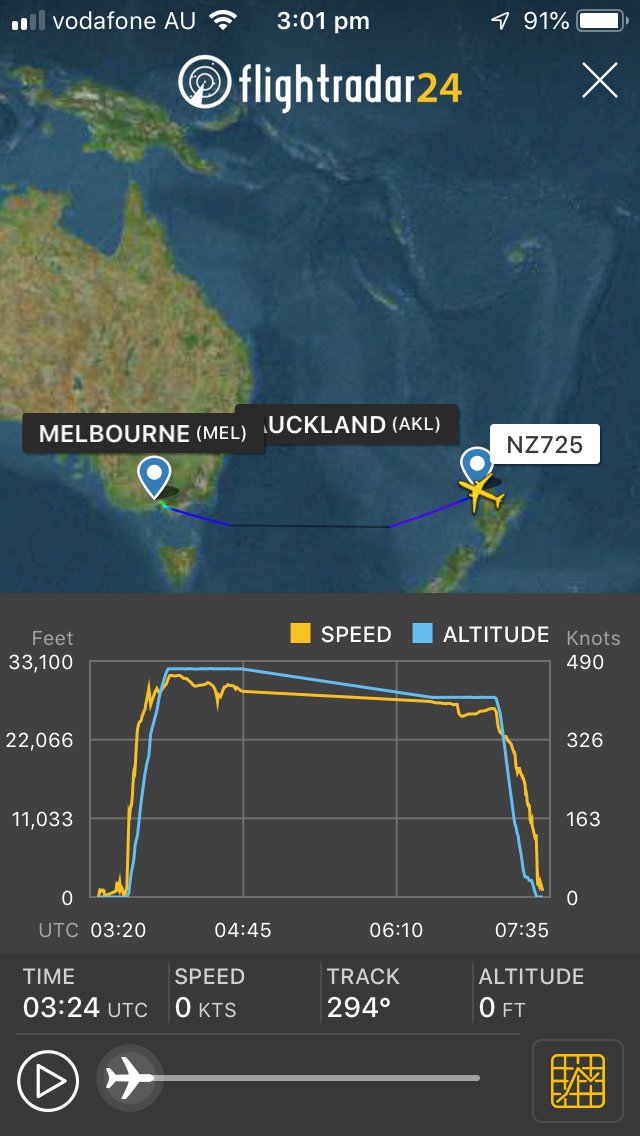
Air NZ aircraft on a slow descent into OZ
Thread Starter
Air NZ aircraft on a slow descent into OZ
Hey all,
I keep an occasional eye on Flight Radar 24, and yesterday I noticed several Air NZ aircraft heading westbound over the Tasman on what could be described as very slow descents. After taking off from NZ and climbing to 35,000ft or so, they then began a very slow descent (about -50 feet per minute) as they crossed the Tasman. Most were at about 25,000ft as they arrived at the Australian coast. Given the strong head winds that were about I am guessing this slow decent helps them keep speed up, but I would be interested to hear from anyone who can tell me more about this procedure.
Cheers, Ants
Do you have a flight number? Itís not a standard procedure that Iím aware of.
Edit: If there are strong headwinds and you wanted to descend out of them, you do a much quicker descent than 50 fpm. Iím wondering if youíve misinterpreted the FR24 data.
Edit: If there are strong headwinds and you wanted to descend out of them, you do a much quicker descent than 50 fpm. Iím wondering if youíve misinterpreted the FR24 data.
Last edited by AerocatS2A; 13th Jun 2019 at 01:10.
Are you sure they are not just exiting FR24 coverage off NZ at 35000 and then being at 25000 when they reenter coverage close to Aus?
There isn't coverage all the way across the ditch.
There isn't coverage all the way across the ditch.
There was a pretty strong (140k) jetstream that reached about half way across the Tasman, yesterday. I'd be guessing they started at a desirable cruise altitude and descended to stay under the jetstream - which was forecast from F410 down to F260. Low alts cost (lots) more in fuel, but likely not as much as loosing 140k ground-speed!
Join Date: Sep 2018
Location: Melbourne
Posts: 2
Likes: 0
Received 0 Likes
on
0 Posts
as we all know it's the time spent in a strong H/W that is the issue. Often A/C are down at mid 20's across the Bite heading towards sand groper country:-) I Tend to go higher say 49K as often the jet stream drops off a bit but few A/C have that ability. Nothing worse than seeing a GS of 300 kts, that's depressing:-(
I use Flight Aware and it has a similar issue.
Example: NZ855 WLG - MEL on the 12th June (local).
The last ADSB data point departing NZ is at 0658 NZST at FL320. The next data point is nearly two hours later at 0851 NZST at FL260. The graphical plot shows a gradual descent between those two points but the flight was actually planned to maintain FL320 until waypoint GILLY where it was planned to descend to FL300. Another descent was planned at LEPAR on the Melbourne FIR boundary to FL260.
Thread Starter

This is an example of the slow descent... several aircraft were leaving NZ at above 30,000ft and then heading into a slow descent... arriving on the Australian coast at about 25,000 ft.
The line is too perfectly straight. Itís just estimating the descent between the last two known locations.
Join Date: Dec 2004
Location: back to the land of small pay and big bills
Age: 50
Posts: 1,218
Likes: 0
Received 0 Likes
on
0 Posts
If you set 1013 hPa on your altimeter and truck out on your planned track..and the environmental pressure drops (for example 1020 over NZ to 1000 over Australia)..what happens?
Not 350 down to 260 by any means but there is still an effect
Not 350 down to 260 by any means but there is still an effect
So for a drop of 20 hPa, your height would drop by 600'.
It's called extrapolation between data points. Unfortunately those data points are hours apart. Want better? Put some ADSB trackers in the Tasman Sea with satellite uplinks.
Once Elon and Jeff get their LEO satellites up, one day every major boat will have these and we won't have stupid MH370 issues.
FR24 will probably give you one for free if you have an uplink.
Once Elon and Jeff get their LEO satellites up, one day every major boat will have these and we won't have stupid MH370 issues.
FR24 will probably give you one for free if you have an uplink.


