


Brooklands EGLB

Thread Starter
Brooklands EGLB
On www.ourairports.com , someone posted "The airfield opens on certain occasions so is definitely not ‘closed’ but needs special permission." Looking at satellite imagery, I find this hard to imagine: there is no marked runway, and no surface that could serve except perhaps part of the car race track.
If the a/d is active occasionally, what kind of occasion would that be?
What part would serve as a runway?
Is the ICAO code EGLB still valid?
If the a/d is active occasionally, what kind of occasion would that be?
What part would serve as a runway?
Is the ICAO code EGLB still valid?

Last time I saw activity it was the grass strip between the Mercedes Benz World track and the offices to the East. I think conditions have to be pretty much perfect. Planes were Tigermoths or similar on a pre-arranged event.
Administrator
Jan,
There's a grass strip running roughly N-S between Mercedes-Benz World to the West and the River Wey to the east that is used as a runway - more recently the N-S tarmac strip in MB World (that used to be the main runway) has also been used. There are annual fly-in events with historic aircraft - google is your friend, as is youtube.
There's a grass strip running roughly N-S between Mercedes-Benz World to the West and the River Wey to the east that is used as a runway - more recently the N-S tarmac strip in MB World (that used to be the main runway) has also been used. There are annual fly-in events with historic aircraft - google is your friend, as is youtube.
And here is some proof!!
The following users liked this post:
Thread Starter
Thanks for responses, all clear now. The "proof" is a bit mysterious, though 
Edit: I have now added the runway to openstreetmap, cfr. https://www.openstreetmap.org/way/1292819449
Did I understand the location all right?
Also, may I be allowed to repeat my question about the ICAO code: is it still valid? It seems unlikely to me, save as a "location indicator" in GEN 2.4
Edit: I have now added the runway to openstreetmap, cfr. https://www.openstreetmap.org/way/1292819449
Did I understand the location all right?
Also, may I be allowed to repeat my question about the ICAO code: is it still valid? It seems unlikely to me, save as a "location indicator" in GEN 2.4
Last edited by Jan Olieslagers; 16th Jun 2024 at 10:35.
Administrator
Jan,
You've got the grass runway correct, but the tarmac to the west of the MB World track (line of original hard runway) is also used.
AFAIK, the ICAO code is still valid.
You've got the grass runway correct, but the tarmac to the west of the MB World track (line of original hard runway) is also used.
AFAIK, the ICAO code is still valid.
There was a fly in last year on what's left of the main runway. (I watched a video somewhere on the twaternet) However, all the visiting a/c had to park at the northern end of the tarmac, thereby making if effectively even shorter and, in the event of brake failure or a long landing, a safety concern. In my humble opinion. I flew in in 1992, before MB did their thing, when off runway parking was still possible. MB, AFAIK, were supposed to make the grass strip available but never did.
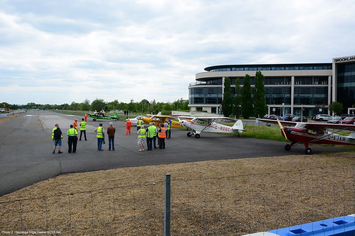
I don't know the ins and outs of the grass runway situation, but this is a photo from a 2023 fly-in. As mentioned, this uses part of the M-B track that is located where the original runway (the north end) used to be. It provides a pretty decent strip with enough clearance at both ends, judging from what I saw and from talking to someone who flew in there. The grass strip is more restricted.
Here is a view from one of the participants:
The following users liked this post:
