


DH9A missing 23 September 1920 Tasmania

Thread Starter
DH9A missing 23 September 1920 Tasmania
Greetings from Tasmania
I am a member of the Tasmanian Aviation Historical Society. Some time ago (our newsletter #6) we published an article on the disappearance of an RAAF DH9A biplane piloted by Captain William Stutt accompanied by his engineer Sergeant Dalzell. The aircraft and crew went missing on 23rd September 1923 whilst searching for a missing schooner the "Amelia J". The area they were searching was the Furneaux Island group and coastal eastern Tasmania. No trace was ever found , however an unverified crash site was mentioned as being found in the 1950's which yielded an oil filter and other bits of suspected aircraft debris.
If the missing aircraft did not go in to the ocean then it lies onshore somewhere. There is some argument that supports an onshore crash site..After 103 years there would not be much to show of a fabric and wood machine..........except the engine block which weighed in excess of 400 kilograms.
We will continue our project to unravel this mystery. Finding the engine block would answer a number of questions. At the moment our research is mainly via the paper trail limited though that is.
If anyone has any information or 21st century) ideas that would assist , it would be greatly appreciated..
Peter Manktelow
Executive Member
TAHS
tahs.org.au

Join Date: Oct 2016
Location: Christchurch
Posts: 74
Likes: 0
Received 0 Likes
on
0 Posts
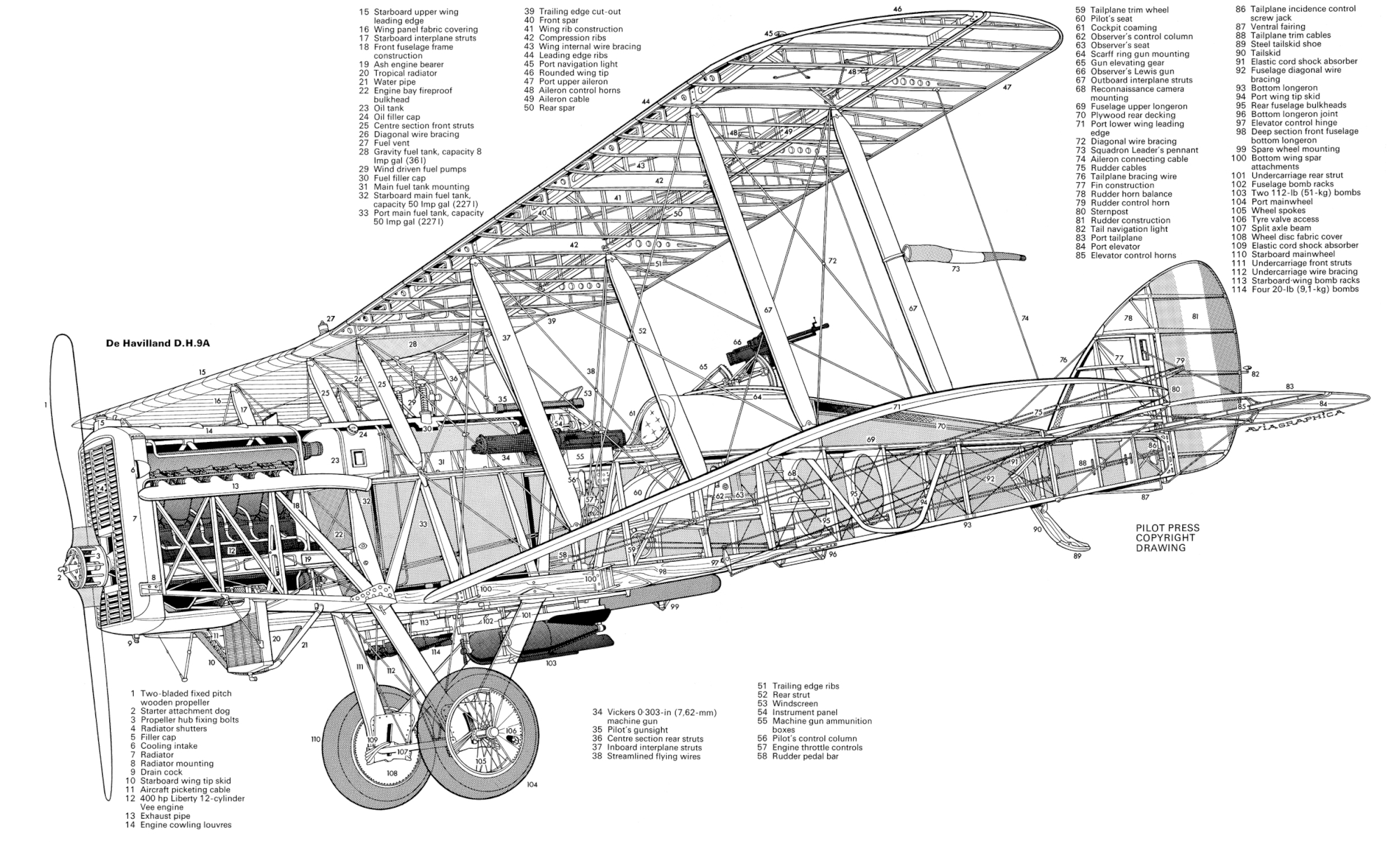
The engine "block" of the American-built Liberty V-12 referred to never existed - this engine had 12 individual cylinders with thin metal water jackets. Largest part of this engine would have been the 2-part crankcase (upper and lower aluminium castings), and the crankshaft would probably have been about as heavy as the crankcase itself, if not more so. Unlike most aero-engines of the era, the Liberty engines were not "fired" by magnetos, having a battery and coil system, also made in America by Delco if I remember correctly.
Last edited by dduxbury310; 18th Jul 2023 at 22:16.
I don't really know anything about aero-engines of that era but I had been thinking that a 400kg, or the thick end of half a ton, lump seemed unlikely and I'd completely forgotten that separate cylinders were pretty much universal then.
According to wiki, the whole aircraft only weighed a ton and a quarter.
According to wiki, the whole aircraft only weighed a ton and a quarter.

The aircraft and crew went missing on 23rd September 1923
Imperial Gift D.H.9a.
Aircraft was packed in UK 03/12/19 and apparently shipped on 09/01/20.
In service with CFS AAC in 1920, when it crashed in Bass Strait on 23/09/20 (crew Capt W J Stutt and Sgt A G Dalzell killed).
Struck off charge 31/12/20 before the RAAF 'A series' started in 08/21
Aircraft was replaced by DH9A A1-30, the final serial
This aircraft was not gifted to Australia, it was purchased to replace E8616, by the approval of the Air Council on 14/06/21, at an estimated cost of 2953 pounds.
This aircraft was reconditioned by de Havilland at Stag Lane (aircraft c/n 42) and was delivered in mid 1923.
Served with 1 FTS from 07/23, crashed at Point Cook 16/08/26. (crew Cdt K M Frewen),
To 1 AD 19/08/26 for storage.
Approved for conversion to components 12/07/27
I had been thinking that a 400kg, or the thick end of half a ton, lump seemed unlikel
https://www.enginehistory.org/Piston...rtyNotes.shtml
I see that 'newsletter #6' has the correct year for this loss (1920). As an aside #6 seemed to contain a lot of interesting information and articles, I'm quite keen to read all of the newsletters when time allows.
Peter, you mention an 'unverified crash site'. Are there any further details around this, co-ordinates, more on the debris etc?
FP.
Peter, you mention an 'unverified crash site'. Are there any further details around this, co-ordinates, more on the debris etc?
FP.
Thread Starter
3 items of debris. A small radiator , possibly the auxiiary radiator fitted for Middle East very hot wx operations. Wire that appeared to be the structural component of the two main wheel tyres and of the correct diameter. Rubber burnt off ? And thirdly a section of aluminium with "D of D" printed on it. T
Thread Starter
the second "D" partly obliterated and could be an "A". This piece of aluminium supposedly had some flush riveting on it. All items left at the crash site in the 1950's. Subsequent visits failed to re-find them.
Thread Starter
The site is difficult to get to. Snake infested. Spider infested. Blade grass. Swampy. And Ross River disease mosquito. Very thick scrub to get to the site.
Thread Starter
Fireball theory
Noyade. I have to find again where the "fireball" theory was discredited but further to that the Cafe Royale affair had 3 x DH9A looking for Smithy's downed aircraft. One of the DH9A had an engine fire on start up at Wave Hill station which destroyed the machine. The Liberty L12 engine was thrown on the rubbish heap then found later and is now on exhibition at the Darwin Aviation Museum minus all but 5 of its cylinders but easily recognised as an L12 that was standard for the DH9A. I then went back to the history of all 31 DH9A that were acquired by the RAAF. Not one had an in flight fire. They sure had a lot of engine failures but no fires..
Peter
Peter
Thread Starter
Have been in to the alleged crash site 3 times now. It is "mongrel" country. Not very pleasant scrub to try and walk thru. Presently in St Helens and hoping to go back in again soon. Courtesy of TasMap , I have a LIDAR (lazer) photograph of the area which indicates a couple of anomalies ie strange shapes that are not common in nature. One is in two parts close together , one in the shape of an "x" and the other a partial "semi circle". The second anomaly is also in the shape of an "x" located about 200 meters north west of the two part anomaly. Our GPS got us within + - 5 metres of these anomalies but the scrub ,both vertically and underfoot was so thick that we could have been standing on the targets and not known it. The baby tiger snake we came across also discouraged us from pushing on. The trouble is , I am lacking the knowledge of LIDAR target interpretation. I would be just as happy for an expert to say that these two targets are just aberrations of the LIDAR detector. If that was the case , I would not have to go back in there !!! There are other parts of the search area yet to be looked at. We reckon we have the area down to about 1 km x 1 km. Any further investigation of the two anomalies mentioned above will require us waiting for a natural burn off OR a scrub clearing operation of monumental proportions. I really wish we had ready access to professional drone/Lidar/magnetometer expertise and of course we are working on a zero budget at the moment which does not help.
The following users liked this post:
Reasonably useful magnetometer sensors are available at affordable prices, and coding a $10 Pico or similar to output something intelligible isn't too difficult (speaking from direct experience here) so there are some options for a comparatively inexpensive grid scan of the site - assuming access to a drone or some other methodology for moving the sensor around. FWIW it may be that a gradiometer setup would produce something more usable than a single mag sensor.
Once collected you can input the resultant data into a suitable GIS program such as QGIS for a visual display of the site archeomagnetic features. QGIS is open-source so even if there isn't a suitable plugin (there are several for commercial mag units) it should be possible to write something in Python or whatever.
I'm a few miles from you so can't help directly but if you've a mind to spend some $$ (let's say < $500) and experiment I'm happy to provide some input.
FP.
Thread Starter
FP , your particular IT language is completely lost on me. This is a common problem.no matter what discipline you hold so please do not take offence. I have no doubt that if I went in to detail about the (Airbus) EC225 that I used to fly , people would similarly not understand what I was talking about..
So where to from here ? I have a vegetation canopy of light to medium density/ cover to fly over (with a drone) and this canopy is something like 15 to 20 meters above ground level. What sensor should I use ? Magnetometer , LIDAR or metal detector or something else ? The target is a 383 kg engine block half aluminum and half ferrous material. I would need to establish a maximum survey height ,and a maximum track spacing. The block may be partially or completely buried.
In terms of cash....sorry , I am skint...at the moment. When we reach the stage where we need to spend real money then I will be looking at grant funds.
I have what I am calling a LIDAR anomaly courtesy of TasMap's hillshade overlay. First and foremost I want to establish what this anomaly is. If it can be confirmed that it is just a coupe of logs fallen over each other then well and good but if it is interpreted as an item of real interest then I have a monumental task of getting in to the exact location..
Peter
.
What sensor should I use ? Magnetometer , LIDAR or metal detector or something else ? The target is a 383 kg engine block half aluminum and half ferrous material.
In terms of cash....sorry , I am skint...at the moment. When we reach the stage where we need to spend real money then I will be looking at grant funds.
I have what I am calling a LIDAR anomaly courtesy of TasMap's hillshade overlay. First and foremost I want to establish what this anomaly is. If it can be confirmed that it is just a coupe of logs fallen over each other then well and good but if it is interpreted as an item of real interest then I have a monumental task of getting in to the exact location..

In terms of sensor; for various reasons I suggest a magnetometer, in this instance you could consider it a sensitive/wide scale metal detector. If you flew a grid pattern over your presumptive area and logged the output of said magnetometer at certain intervals you might expect an anomalous result nearby the engine block.
To put it another way; if you took a piece of grid paper and drew a small block somewhere on the page to represent the engine block. Then put a number (say '5') at the each intersecting line of the grids until you get nearby the block you've drawn .. at that point, as you get nearer the block, you might increase the '5' to 6,7,8 etc 'till above the block you made it a '12' (for the sake of this example). The '5' number represents the earth's magnetic field as measured by the sensor at that time, whereas the increasing numbers represent that +/- the field introduced by the block. Plotted on the paper, or via computer in a Geographic Information System (GIS), you can see a representation of the block as something anomalous to the rest of the environment without visually clapping eyes on the actual block itself - ie. it can be underground or under-bush, but the magnetic anomaly will represent it.
In practice the paper grid intersection points may be a GPS point, or an interval measured in another way (eg timed recordings taken as the sensor travels at at a constant speed in a specified direction). The reading for each point can be transferred to a GIS package and correlated with the ground surface to show where any anomalies lay.
A magnetic gradiometer comprises two mag sensors, one of which samples the environmental field, the other the local field (ie. close to the ground here) and you plot the gradient between them. In this instance you're looking for a change in the gradient that might represent the engine block. For various reasons a gradiometer may be preferred, but that's a story for another day.
Hopefully that helps to explain one method of magnetic anomaly detection and plotting. There are others, and there are various practical issues that can occur, but I think this is an broad view of of how it works. Please ask for any clarification you need, and if anyone else spots any glaring errors/omissions, or is able to put things a better way, please pile in.
Can't help with the $$ but a rudimentary system (excluding drone or other transport system) could be constructed for a few hundred $$, so perhaps when you get some money you might like to revisit.
In terms of LiDAR. You've not said whether you're analysing the data yourself, or using an existing graphic, but you may want to consider looking at the different elevations that may be available. A simple explanation of what I'm talking about may be found here. From this you might be able to better determine whether what you're presently seeing is a man-made object above the normal terrain, or something else. I stress that it'd be fairly tenuous in my view, but probably worth the exercise. Once again you can use a GIS for this, and suggest that a package known as Quantum GIS or QGIS would be a good start. There would be quite a learning curve, but if you can drive something like a Super Puma then I reckon this should be a doddle

Finally on this, if the LiDAR dataset is publically available you could let me know whereabouts, and the specific location of interest, and I may be able to find some time to analyse it here. No guarantees, but I don't mind having a look should time permit.
FP.
