


Southwest Low Altitude Alert OKC

Thread Starter
Southwest Low Altitude Alert OKC
https://www.flightradar24.com/blog/s...titude/?fbclid
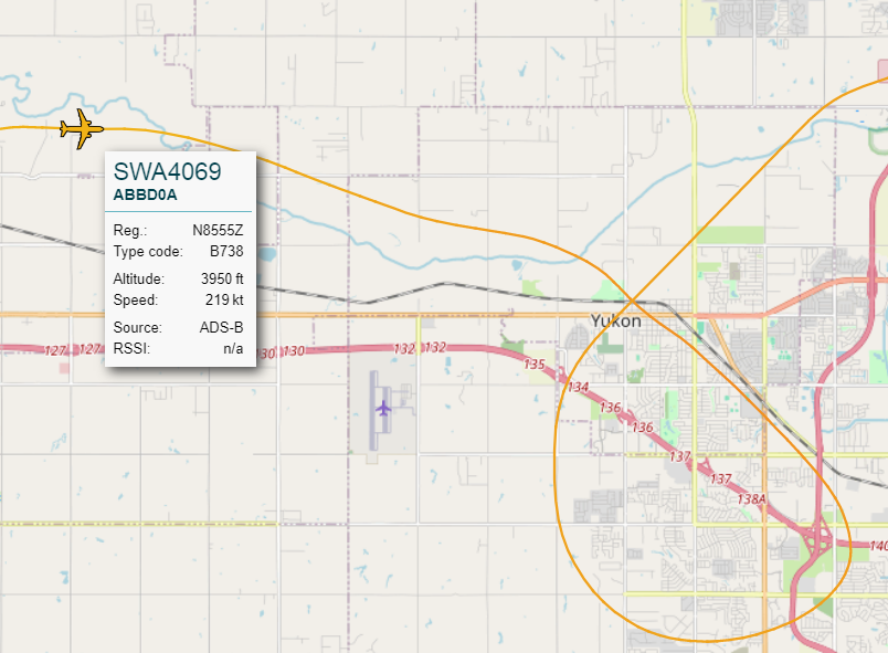
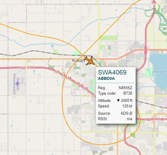
Air traffic controllers in Oklahoma City received a low altitude alert for Southwest Airlines flight 4069 as it approached Will Rogers World Airport just after midnight local time on 19 June. The aircraft had been cleared for an approach to the airport’s Runway 13 when it descended to approximately 525 feet above the ground about 9 miles from the airport. The incident was first reported by The Oklahoman on 20 June.
Air traffic controllers in Oklahoma City received a low altitude alert for Southwest Airlines flight 4069 as it approached Will Rogers World Airport just after midnight local time on 19 June. The aircraft had been cleared for an approach to the airport’s Runway 13 when it descended to approximately 525 feet above the ground about 9 miles from the airport. The incident was first reported by The Oklahoman on 20 June.
"Southwest 4069, low altitude alert. You good out there?"
Last edited by Lake1952; 21st Jun 2024 at 11:14.

Pegase Driver
I hope not another wrong QNH on an RNP , but it can bite you the same on a visual at night if you only are looking outside , but 9 MN out ?
That said I love the � You good out there ? � from the controller . Nice new phraseology.
That said I love the � You good out there ? � from the controller . Nice new phraseology.
The following 4 users liked this post by ATC Watcher:
Modern technology would allow local QNH ('altimeter' in American parlance) to be transmitted automatically into FMCs to reduce the chances of mis-setting. The pilots' job would be to check that the auto setting was reasonable, based on latest received METARs, and to override it if appropriate.
Something along these lines:
Something along these lines:
Around 2,000 feet lower than expected would require an altimeter setting error of approximately 70 hPa - sounds a tad unlikely.
Pegase Driver
A question for US pilots , does the verification by ATC of mode C altitude on first contact with APP still systematically performed in the US ?
It�s been a while since I have flown IFR there .
From LiveATC:
SWA cleared for visual 13, stay with approach (app/twr/ground combined)
ATC issues low altitude alert
SWA announces going around
ATC queries if SWA wants to come back around for 13 or continue approach
SWA requests “come back around for 17”
ATC queries 17R
SWA says “yeah, we’ll do that”
ATC vectors SWA for 17R, ultimately clears SWA for visual 17R
No further discussion between ATC and SWA regarding low-altitude alert
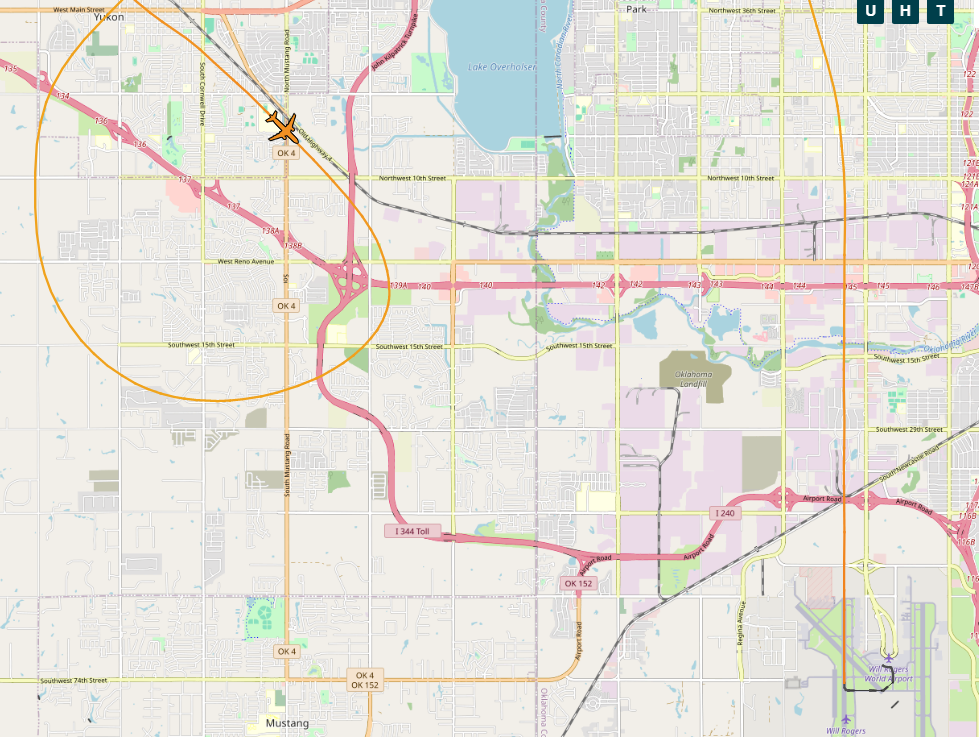
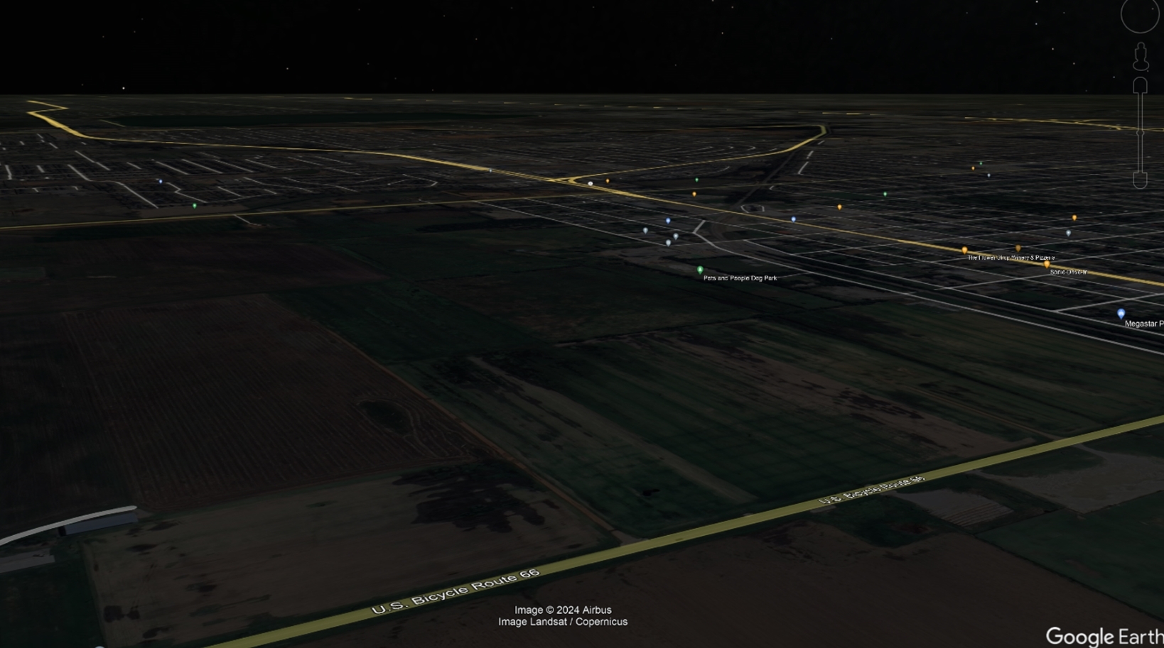
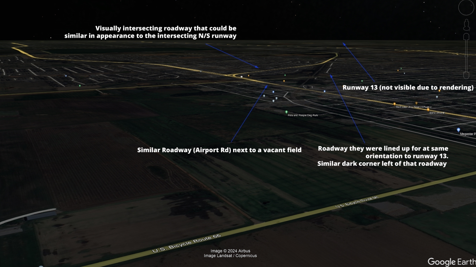
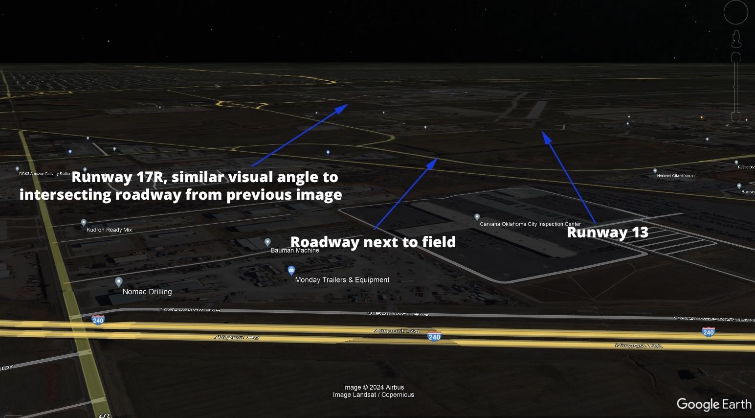
Note that ATIS was broadcasting a “be alert” for the potential to confuse KPWA 8.8 mi NW with KOKC as both have similar runway configurations. However, SWA was never aligned with the KPWA 13 extended centerline. Instead, SWA was aligned with a section of a rail line that parallels state road 4.
SWA cleared for visual 13, stay with approach (app/twr/ground combined)
ATC issues low altitude alert
SWA announces going around
ATC queries if SWA wants to come back around for 13 or continue approach
SWA requests “come back around for 17”
ATC queries 17R
SWA says “yeah, we’ll do that”
ATC vectors SWA for 17R, ultimately clears SWA for visual 17R
No further discussion between ATC and SWA regarding low-altitude alert
Note that ATIS was broadcasting a “be alert” for the potential to confuse KPWA 8.8 mi NW with KOKC as both have similar runway configurations. However, SWA was never aligned with the KPWA 13 extended centerline. Instead, SWA was aligned with a section of a rail line that parallels state road 4.
The following users liked this post:
I dislike visual approaches at night with a passion, however I�ll accept it with the understanding from the rest of the crew that we will fly one of the charted approaches with lateral and vertical guidance.
Quick check shows that RWY 13 has an RNAV approach and the charted altitude at 9 miles is 4000� which is about 2700-2800 AGL.
The IRW VOR appears to be 3NM from the airport but even quick mental math with DME showing 12 miles would have been 5000�
instead of 1700-1800�.
Quick check shows that RWY 13 has an RNAV approach and the charted altitude at 9 miles is 4000� which is about 2700-2800 AGL.
The IRW VOR appears to be 3NM from the airport but even quick mental math with DME showing 12 miles would have been 5000�
instead of 1700-1800�.
The following users liked this post:
The following users liked this post:
BFSGrad
BFSGrad: "...However they were aligned with a section of railroad tracks....,"
IFR. "I Fly Railroad"
From the sectional, they may have been anticipating a side step, tracks to concrete ( I Kid)...
IFR. "I Fly Railroad"
From the sectional, they may have been anticipating a side step, tracks to concrete ( I Kid)...
The following users liked this post:
The following 2 users liked this post by Flch250:
The following 2 users liked this post by Lake1952:
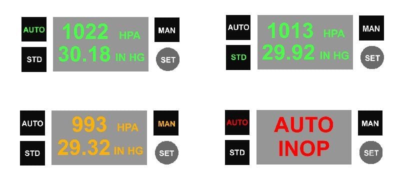
190452Z 14011KT 10SM FEW060 FEW200 SCT250 26/20 A2996 RMK AO2 SLP129 T02560200
29.96 inHg = 1014.5 hPa. This suggests the altimeter was set correctly.
I also looked at the ADS-B Exchange data for the lowest GPS altitude during the incident and found 1700ft (WGS-84). Using EGM96 I get an aircraft altitude of ~1790 ft msl. The ground elevation in that area is about 1340ft, so I estimate that the aircraft was about ~450 ft AGL (this is a little lower than other estimates I have seen of 525ft). The 450ft value matches the ADS-B exchange estimate found when examining the exporting KML.
The following users liked this post:
KOKC RNAV RWY 13 shows 4000 ft for all the IAF to IF legs. Correcting the ADS-B reported altitude for field elevation shows aircraft level at 4000 ft before there is a reduction in reported FMS SEL ALT and the aircraft starts to descend again.
The altitude and altimeter setting appear to have been reasonable at that point in the approach.
WABUT, the IF, is close to the point where the railroad turns SE and, if following the RNAV approach constraints, the aircraft should have still been at 4000 ft at WABUT. It had descended to about 2050 ft near WABUT.
I have no explanation for the early descent but incorrect altimeter setting does not appear to have been the cause.
Last edited by EXDAC; 21st Jun 2024 at 22:27. Reason: add graphic
Agreed but I mentioned road and tracks as possible explanation of what SWA pilots may have taken to be a �runway� well short of the actual runway; i.e., something man-made, linear, lighted, and parallel to actual runway.
Some potential similarity with June 2022 incident where a Fedex 757 landed on the wrong runway at KTUL. NTSB opined:
��the flight crew appeared to discount the information their instruments were providing in favor of the view they had of the runway and understanding of their circumstances.�
Note that two SWA flights that landed just prior to 4069 elected to land on the 17s (MALSR, HIRL).
Join Date: Dec 2019
Location: LA, CA
Posts: 5
Likes: 0
Received 0 Likes
on
0 Posts
This may be helpful into assessing what transpired:
Absolutely egregious and unacceptable on all counts.
Absolutely egregious and unacceptable on all counts.
Last edited by Senior Pilot; 22nd Jun 2024 at 00:05. Reason: Edit URLs and dross
I extracted the "MCP/FCU selected altitude" from ADS-B Exchange and in the picture below I show approximately when it changed during the incident time frame. Note that the resolution of the ADS-B MCP altitude data is 16', which is why you see 2496' instead of 2500'.:
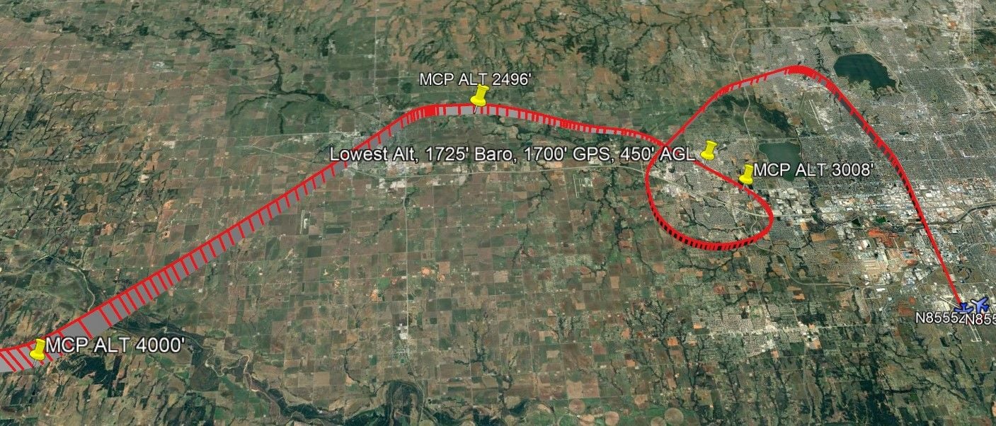
After the "missed approach" the FMC SEL ALT remained at 3008 until landing. The missed approach altitude for RNAV 13 and ILS 17R is 3000 so that seems reasonable.
The following users liked this post: