


Southwest Low Altitude Alert OKC

Originally Posted by Exdac
It looks like perfect alignment with KOKC RW 13 centerline to me.
Originally Posted by Lake 1952
And this is yet another "incident" where the CVR and FDR are of no use in understanding what took place.
Originally Posted by Exdac
KOKC RNAV RWY 13 shows 4000 ft for all the IAF to IF legs.
Originally Posted by Exdac
I could see no reason for the reduction in FMS SEL ALT before intercepting the final approach course. Nor could I explain why the aircraft descended below the 2496 SEL ALT.
Originally Posted by FLCH250
Has anyone seen mention of EGPWS alerting? Odd. Should have been screaming, they were not on an approach.

I only referenced RNAV 13 to establish reasonable altitudes for each aircraft position. It's clear they were not following it.
Originally Posted by Exdac
I only referenced RNAV 13 to esablish reasonable alitudes for each aircraft position.
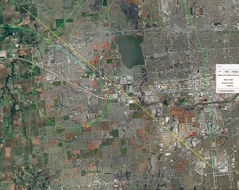
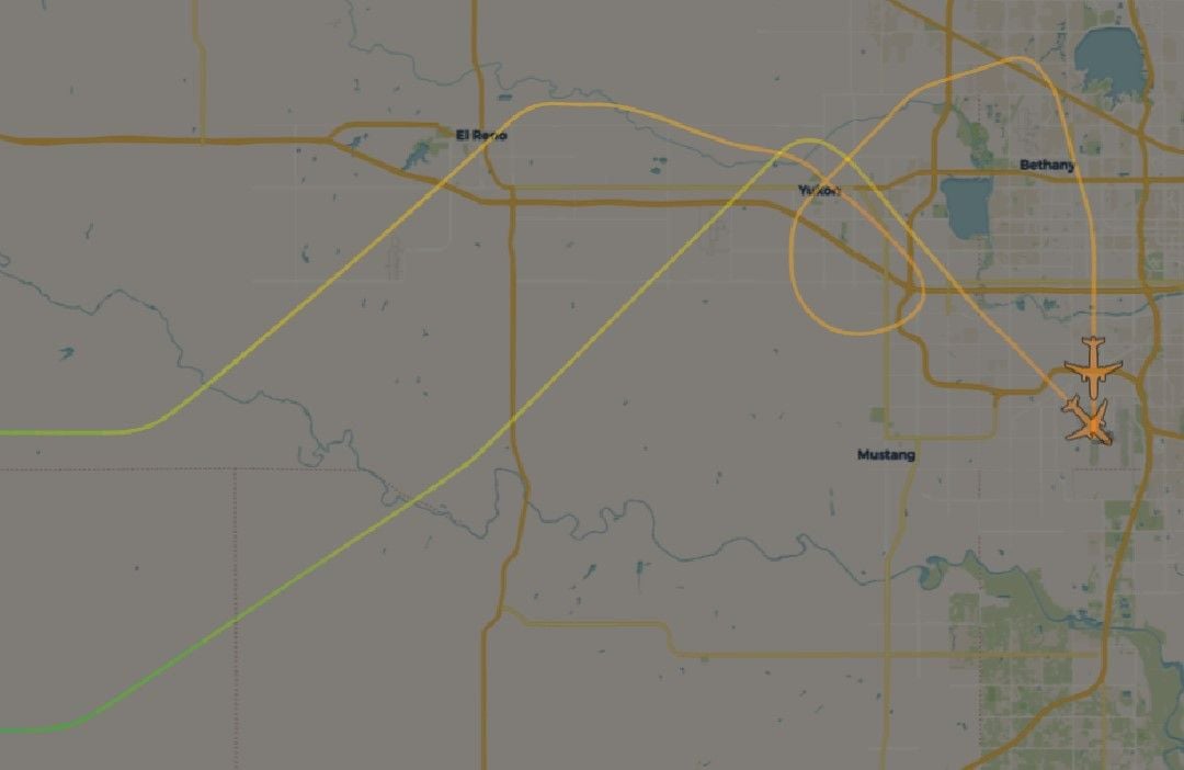
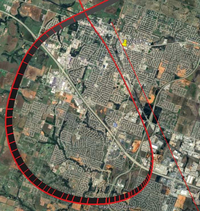
I came here to offer this suggestion. I see others have uploaded images already but thought I'd leave this here for consideration anyway.
Circled about where they were, and about where they were meant to be.
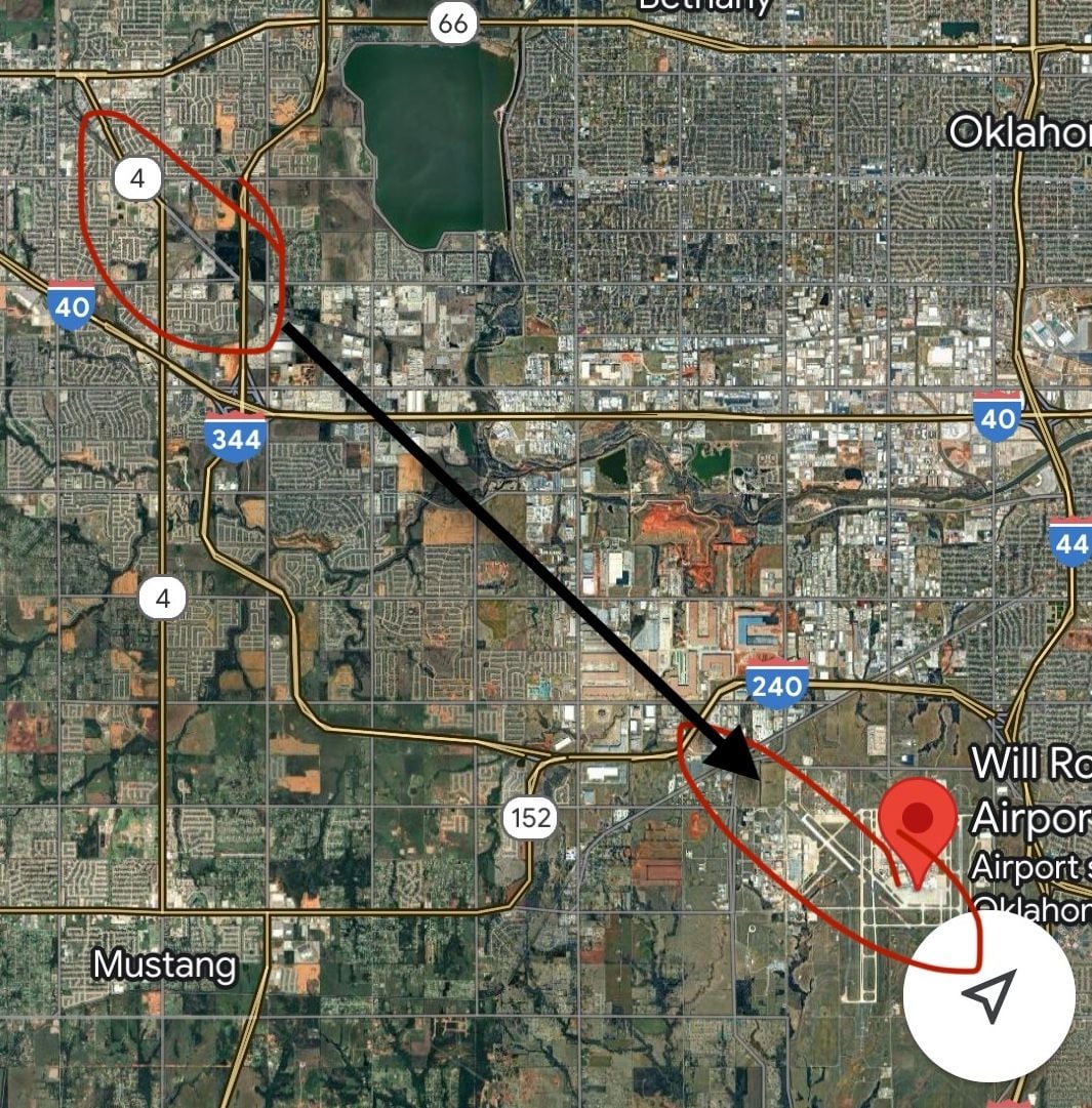
Circled about where they were, and about where they were meant to be.
The following users liked this post:
I find it amazing in these days of moving maps, GPS position, VNAV/RNAV, DME, etc. that an aircraft can get lost on finals in CAVOK. Yes, it�s a visual approach but it doesn�t make you any less of a pilot to do a few gross error checks with the information you have other than the view out of the window, which can lead to confirmation bias...
Not to me it doesn't. They are off to the right/southwest. And the runway's miles away. Don't know how many night visual approaches you've done in these, but visually lining up on a runway that is ~8nm is not the easiest thing in the world, if you can see it at all amoung the lights.
The following users liked this post:
Thread Starter
AATC Transcript
From the live ATC recording starting at approximately 0500Z, a transcript:
T+2:30:
SWA4069: 4069, field in sight.
Approach: SWA4069, cleared visual approach runway 13, remain this frequency, cleared to land.
SWA4069: Cleared for the visual 13, stay with you, and cleared to land, SWA4069.
T+6:30:
Approach: SWA4069, low altitude alert, are you doing okay?
SWA4069: Yeah, we'll go around, 4069.
T+7:00:
Approach: You want to go around and come back for 13 or you gonna continue with the approach?
SWA4069: Yeah we'll come back around for 17.
Approach: Okay, 17 right?
SWA4069: Yeah we'll do that.
Approach: 4069, maintain 3000, and it'll be like a right 180 turn right heading of 360 maintain 3000 for runway 17 right.
SWA4069: Alright, right turn 360, SWA4069.
T+9:04:
Approach: SWA4069, turn right heading 050.
SWA4069: Right turn 050, SWA 4069.
T+10:21:
Approach: SWA4069, turn right heading 080, the field will be off to your right 10 miles.
SWA4069: Right turn 080 SWA4069.
T+11:13:
Approach: SWA4069, turn right heading 145.
SWA4069: Alright, 145, SWA4069.
T+11:54:
Approach: SWA4069, turn right heading 160. Field 1 o'clock 9 miles.
SWA4069: Alright, 160, 4069, we've got the field in sight.
Approach: SWA4069, cleared visual approach 17 right, remain this frequency, cleared to land.
SWA checks in at 10K with info E (ATIS landing ILS 17s, RNAV 13)
ATC queries runway preference
SWA requests runway 13
ATC descend to 6K, expect 13
ATC turn right 050, vectors to final, descend to 4K
Thread Starter
I realize that investigators are early in the process of trying to understand what happened in the OKC incident as well as the LIH busted minimums and the off course busted minimums LGA ATC "flyby" in March where an aircraft passed over the tower by less than a hundred feet. But without meaning to be overly controversial, are we seeing a pattern here with WN crews and loss of situational awareness? Even the 2023 Austin incident with the Fedex 767 showed what I find others felt to be terrible situational awareness on the part of the departing Southwest 737 crew by calling "ready" when still several hundred feet short of the runway hold line and then doing a run up after being notified of the 767 on 3 mile final. And in both the OKC and LGA incidents, it was a tower controller that caught pretty precarious low altitude issues, not the crews.
FAA investigating Southwest flight that flew just 525 feet above Oklahoma town, triggering altitude warning
If a jet flew 525 feet above my house nine miles out from the airport, I�d notice.
If a Cessna 152 flew 525 feet above my house, I�d notice.
What happened?
The following users liked this post:
Join Date: Jul 2007
Location: Auckland, NZ
Age: 79
Posts: 724
Likes: 0
Received 0 Likes
on
0 Posts
"Approximately one minute later, the approach controller, noting that the reported altitude of Flight 401 was 900 feet, and knowing that the flight was assigned 2,000 feet, queried the flight crew as to their status saying, "How are things comin' along out there?" But, he did not specifically mention altitude in his radio call."
The controller in this case specifically mentions an altitude alert.
Join Date: Nov 2004
Location: Here, there, and everywhere
Posts: 1,146
Likes: 0
Received 19 Likes
on
12 Posts
Really, this sort of incident typically comes down to not paying attention to the ND. It is pretty much all right there on the display(unlike the old days in the steam guage cockpits). Back then, you used an ADF needle(or RMI) for situational awareness, ideally with some DME info and maybe the approach tuned in.
There seems to be a tendency to just go for the first set of lights that look like a place to land. In addition, some like to always, proudly hand-fly in visual conditions instead of hand-fly at the appropriate time. Not sure about this flight but why not just have it on autopilot and be doing a good search outside and scan at the ND with much more concentration capability. Then disconnect the autopilot when the landing location is confirmed inside and outside.
There seems to be a tendency to just go for the first set of lights that look like a place to land. In addition, some like to always, proudly hand-fly in visual conditions instead of hand-fly at the appropriate time. Not sure about this flight but why not just have it on autopilot and be doing a good search outside and scan at the ND with much more concentration capability. Then disconnect the autopilot when the landing location is confirmed inside and outside.
Join Date: May 2011
Location: Metropolis
Posts: 1,276
Likes: 0
Received 0 Likes
on
0 Posts
Worth revisiting the January 2014 incident where a SWA 737-700 landed at the wrong airport. In that incident (DCA14IA037), the NTSB found that the flight crew “failed to comply with procedures for use of navigation information and visual cues to verify the airport and runway of intended landing.” Although the PF/FO briefed the visual 14 at KBBG with the RNAV 14 as a backup, once the flight crew had the [wrong] airport in sight (KPLK), the PF and PM ignored all electronic navigation information and proceeded visually, culminating in a landing on runway 12 (3,500 ft LDA) at KPLK. Following this incident, SWA revised the AOM to include runway lighting as a component in visual approach briefings.
SWA Land at Wrong Airport
SWA Land at Wrong Airport
It only shows fixes in front of the nose, so it is useless for this, unless you're on a long final. And in that case, it's superfluous since you probably have an instrument approach loaded already that you're following with VNAV and/or the glide slope.
