


JAL incident at Haneda Airport

Re: Location of Impact
A framegrab from an early video shows the moment of impact (or explosion) from a surveillence camera:
Using Google Maps I have made this VERY VERY ROUGH map:

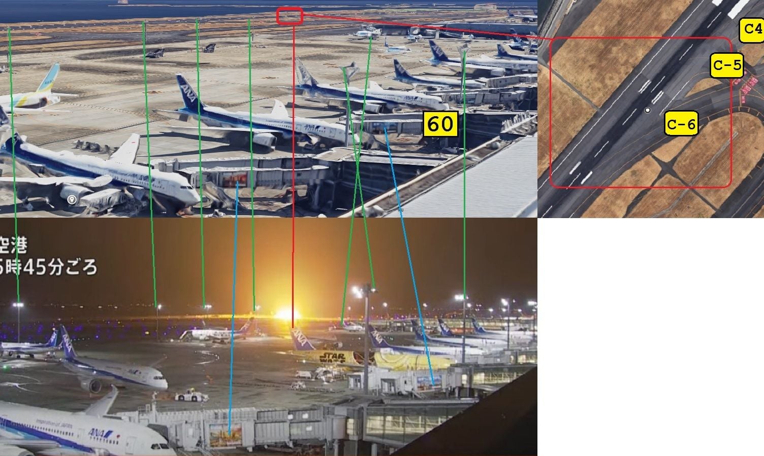
The Red line of sight is judged by counting the number of stands seen on the East terminal. And it would be logical to place such a camera where almost all of the East Terminal Apron can be surveilled.
And the explosion is surely seen to be way "beyond" the end of East Term, (Green Line)?
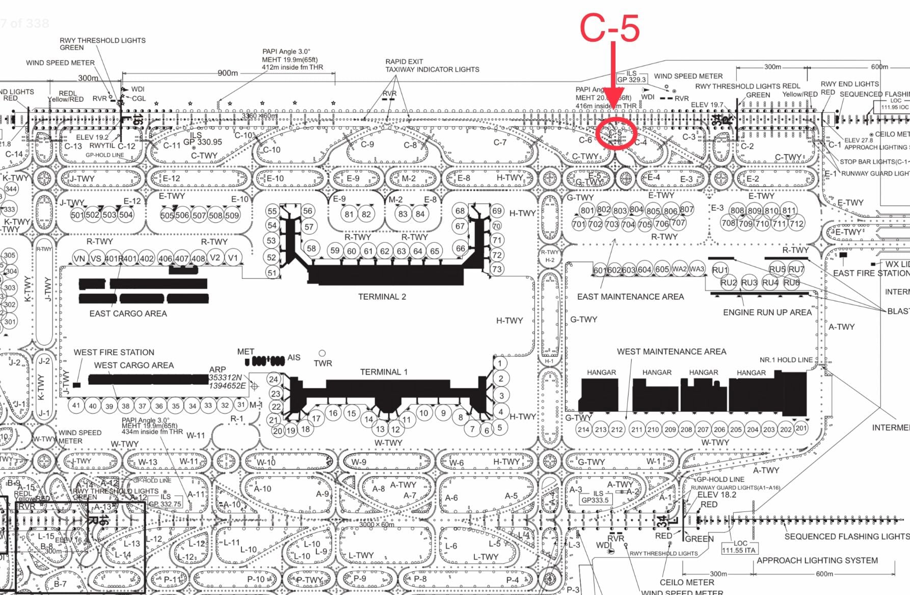
So I am puzzled how the Coast Guard plane could have entered on C5 (Orange Text), which is only half way along East Term?
IB
A framegrab from an early video shows the moment of impact (or explosion) from a surveillence camera:
Using Google Maps I have made this VERY VERY ROUGH map:
The Red line of sight is judged by counting the number of stands seen on the East terminal. And it would be logical to place such a camera where almost all of the East Terminal Apron can be surveilled.
And the explosion is surely seen to be way "beyond" the end of East Term, (Green Line)?
IB
Last edited by Ivor_Bigunn; 3rd Jan 2024 at 10:36. Reason: Deleted Apparently Incorrect Taxiway Numbers

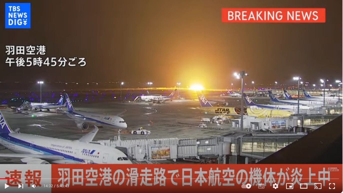
BBC News - Japan Airlines plane in flames on the runway at Tokyo's Haneda Airport
https://www.bbc.co.uk/news/world-67862011
https://x.com/FlightEmergency/status...A3H9D5LpQ&s=09
https://www.bbc.co.uk/news/world-67862011
https://x.com/FlightEmergency/status...A3H9D5LpQ&s=09
Just received Airbus official statement Airbus statement on Flight JAL516, 02 January 2024
@Airbus
Toulouse, 02 January 2024 - Airbus regrets to confirm that an A350-900 operated by Japan Airlines was involved in an accident during flight JAL516 from Sapporo New Chitose Airport to Haneda International Airport shortly after 17:47 (local time) on 02 January 2024. All 367 passengers and 12 crew members on-board evacuated the aircraft.
The A350 collided with a DHC-8 aircraft at landing in Haneda. The Japanese authorities have since confirmed that sadly five of the six people on board the DHC-8 did not survive. The exact circumstances of the event are still unknown.
The aircraft involved in the accident, registered under the number JA13XJ, was MSN 538, delivered to Japan Airlines from the production line on 10 November 2021. It was powered by Rolls-Royce Trent XWB engines.
In line with International Civil Aviation Organization (ICAO) Annex 13 recommendations, Airbus will provide technical assistance to the Bureau d�Enqu�tes et d�Analyses (BEA) of France and to the Japan Transport Safety Board (JTSB) in charge of the investigation. For this purpose, Airbus is presently dispatching a team of specialists to assist the Authorities.
Further updates will be provided as soon as consolidated information is available and Airbus is authorised to release them.
Our concerns and sympathy go to the families, friends and loved ones affected by the accident.

Airbus newsroomAirbus statement on Flight JAL516, 02 January 2024
@Airbus
Toulouse, 02 January 2024 - Airbus regrets to confirm that an A350-900 operated by Japan Airlines was involved in an accident during flight JAL516 from Sapporo New Chitose Airport to Haneda International Airport shortly after 17:47 (local time) on 02 January 2024. All 367 passengers and 12 crew members on-board evacuated the aircraft.
The A350 collided with a DHC-8 aircraft at landing in Haneda. The Japanese authorities have since confirmed that sadly five of the six people on board the DHC-8 did not survive. The exact circumstances of the event are still unknown.
The aircraft involved in the accident, registered under the number JA13XJ, was MSN 538, delivered to Japan Airlines from the production line on 10 November 2021. It was powered by Rolls-Royce Trent XWB engines.
In line with International Civil Aviation Organization (ICAO) Annex 13 recommendations, Airbus will provide technical assistance to the Bureau d�Enqu�tes et d�Analyses (BEA) of France and to the Japan Transport Safety Board (JTSB) in charge of the investigation. For this purpose, Airbus is presently dispatching a team of specialists to assist the Authorities.
Further updates will be provided as soon as consolidated information is available and Airbus is authorised to release them.
Our concerns and sympathy go to the families, friends and loved ones affected by the accident.
Miracle the pax and crew manage to escape the burning A350...

Join Date: Apr 2008
Location: Lisbon
Age: 62
Posts: 2
Likes: 0
Received 0 Likes
on
0 Posts
The underside of the A350 was in shreds, from the front gear bay to almost the tail. It "ran over" the DHC-8. I'd venture that the nose cone broke the vertical stabilizer of the coast guard plane, and then everything went under.
Assuming 180t landing mass and 122kts touchdown/impact speed for the A350 and 18t takeoff mass for the -8 at 0 speed, a fully elastic collision would decrease the speed of the A350 by about 20kts only. Of course this was not an elastic collision and most of the energy went into deforming parts of both aircraft, so it would decelerate the A350 substantially less than 20kts.
As others have stated, we don't see the -8 in ADS-B data because it doesn't have an ADS-B capable transponder and thus will only be shown on flight tracking sites where MLAT data can be generated. RJTT doesn't have good enough ground coverage by multiple receivers, hence no MLAT position shown.
TCAS is inhibited from providing RAs below 900ft GND. So even if the -8 had an ADS-B transponder, I don't think the A350 crew would have received any warnings. Runway incursion warning systems AFAIK operate only on the ATC side.
Join Date: Jul 2004
Location: Found in Toronto
Posts: 615
Likes: 0
Received 0 Likes
on
0 Posts
Re: Location of Impact
A framegrab from an early video shows the moment of impact (or explosion) from a surveillence camera:
Using Google Maps I have made this VERY VERY ROUGH map:
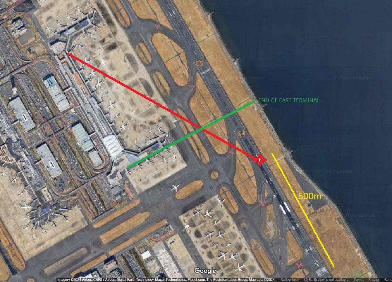
The Red line of sight is judged by counting the number of stands seen on the East terminal. And it would be logical to place such a camera where almost all of the East Terminal Apron can be surveilled.
And the explosion is surely seen to be way "beyond" the end of East Term, (Green Line)?
So I am puzzled how the Coast Guard plane could have entered on C5 (Orange Text), which is only half way along East Term?
IB
A framegrab from an early video shows the moment of impact (or explosion) from a surveillence camera:
Using Google Maps I have made this VERY VERY ROUGH map:
The Red line of sight is judged by counting the number of stands seen on the East terminal. And it would be logical to place such a camera where almost all of the East Terminal Apron can be surveilled.
And the explosion is surely seen to be way "beyond" the end of East Term, (Green Line)?
So I am puzzled how the Coast Guard plane could have entered on C5 (Orange Text), which is only half way along East Term?
IB
Join Date: Jul 2016
Location: The Hague
Posts: 8
Likes: 0
Received 0 Likes
on
0 Posts
My take on the impact, just from the photos and videos, is how surprisingly little damage there is to the A350. The nosecone is very light structure, yet only has a dent, and both engines appear to have light damage to their intakes.
Therefore one must assume that most of the A350 impact was taken on the lower front hull and nose landing gear.
Obviously we don�t yet known the 2 aircraft�s configuration at impact but it�s still difficult to see how the bigger aircraft got away with such little obvious damage, particularly to the wing structure.
AGeeknologist/status/1742210072682369284?t=2Fsl58VGYSxmqsvUKSgMgQ&s=19
(not allowed to post full urls yet)
I was looking at the TBS video, three takes from that:
Left side aft door - steeps slide ... at 0129 the first person out is visible at the bottom of the slide, at 0130 the second, one of the first walks around to grab a bag, then others come down, on top a crew member with a flashlight is constantly visible in the door opening, this person goes down the slide at 0341 with (probably) two other crew including (probably) on of the pilots... they then run to the nose section and (probably) meet the other crew members there... so 2min12 sec from first person down to last out...
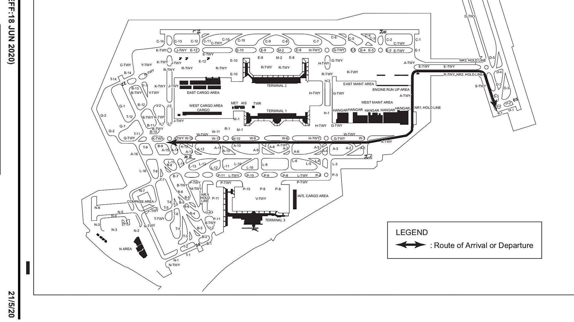
in the middle of the (long, 5hrs) video you see a plane pass right to left hand at high speed past a sign which stands just right of an intersection, ... the sign says ... [ 16L - 34R ][ C5 ] ... not possible to read the registration number (which is some indication of speed) ...
Just like one of the posters above I never got an answer to questions about various effects of fires on large commercial composites fuselages, this video gives some indication of the burn through sequence, pity that the video contains a lot of repeats so you dont have a continuous timeline...
Left side aft door - steeps slide ... at 0129 the first person out is visible at the bottom of the slide, at 0130 the second, one of the first walks around to grab a bag, then others come down, on top a crew member with a flashlight is constantly visible in the door opening, this person goes down the slide at 0341 with (probably) two other crew including (probably) on of the pilots... they then run to the nose section and (probably) meet the other crew members there... so 2min12 sec from first person down to last out...
in the middle of the (long, 5hrs) video you see a plane pass right to left hand at high speed past a sign which stands just right of an intersection, ... the sign says ... [ 16L - 34R ][ C5 ] ... not possible to read the registration number (which is some indication of speed) ...
Just like one of the posters above I never got an answer to questions about various effects of fires on large commercial composites fuselages, this video gives some indication of the burn through sequence, pity that the video contains a lot of repeats so you dont have a continuous timeline...
With the correction of Lost in Saigon that all makes sense.
I was looking at the TBS video, three takes from that:
Left side aft door - steeps slide ... at 0129 the first person out is visible at the bottom of the slide, at 0130 the second, one of the first walks around to grab a bag, then others come down, on top a crew member with a flashlight is constantly visible in the door opening, this person goes down the slide at 0341 with (probably) two other crew including (probably) on of the pilots... they then run to the nose section and (probably) meet the other crew members there... so 2min12 sec from first person down to last out...
in the middle of the (long, 5hrs) video you see a plane pass right to left hand at high speed past a sign which stands just right of an intersection, ... immediately after the flash of (probably) the impact .... the sign says ... [ 16L - 34R ][ C5 ] ... not possible to read the registration number (which is some indication of speed) ...
Just like one of the posters above I never got an answer to questions about various effects of fires on large commercial composites fuselages, this video gives some indication of the burn through sequence, pity that the video contains a lot of repeats so you dont have a continuous timeline...
Pegase Driver
As others have stated, we don't see the -8 in ADS-B data because it doesn't have an ADS-B capable transponder and thus will only be shown on flight tracking sites where MLAT data can be generated. RJTT doesn't have good enough ground coverage by multiple receivers, hence no MLAT position shown.. TCAS is inhibited from providing RAs below 900ft GND. So even if the -8 had an ADS-B transponder, I don't think the A350 crew would have received any warnings. Runway incursion warning systems AFAIK operate only on the ATC side.
The Air Canada Gimli Glider 767 lost its nose gear resulting in the rear slides hanging straight down. A number of passengers who took the rear slides were permanently disabled with spinal injuries.
In this case it seems the left rear slide reached the ground at a bit less than vertical and those coming down there were able to walk away, but may have suffered injuries.
In this case it seems the left rear slide reached the ground at a bit less than vertical and those coming down there were able to walk away, but may have suffered injuries.
ATC Watcher,
He�s quite correct that A/C fitted with ADSB OUT are visible on flight radar while on the ground if the transponder is on.
He�s also correct that TCAS is inhibited below 900ish ft but that�s not really relevant. We sometimes get a TCAS target with the orange (TA) symbol from a/c on the ground visible on the ND but never a TA or RA.
Aircraft do not land at the threshold. Try a 1/4 of the way down of the runway or further. I happen to have an office on an airport and have never seen a B73, A320, B77, B78, turboprops etc land anywhere near a threshold. Always way down the runway.
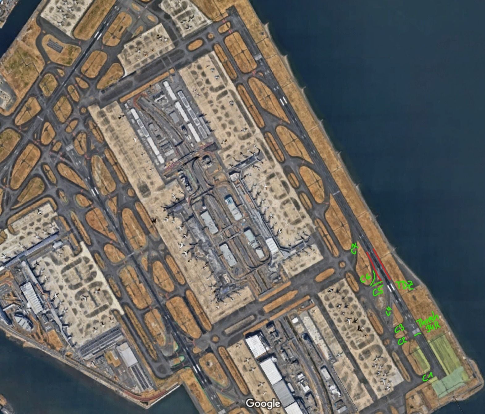
Re: Location of Impact
The Red line of sight is judged by counting the number of stands seen on the East terminal. And it would be logical to place such a camera where almost all of the East Terminal Apron can be surveilled.
And the explosion is surely seen to be way "beyond" the end of East Term, (Green Line)?
So I am puzzled how the Coast Guard plane could have entered on C5 (Orange Text), which is only half way along East Term?
Indeed, you see part of the 'aiming point' in the top right corner of my picture.
Last edited by DIBO; 2nd Jan 2024 at 17:38. Reason: Added reply to DTS
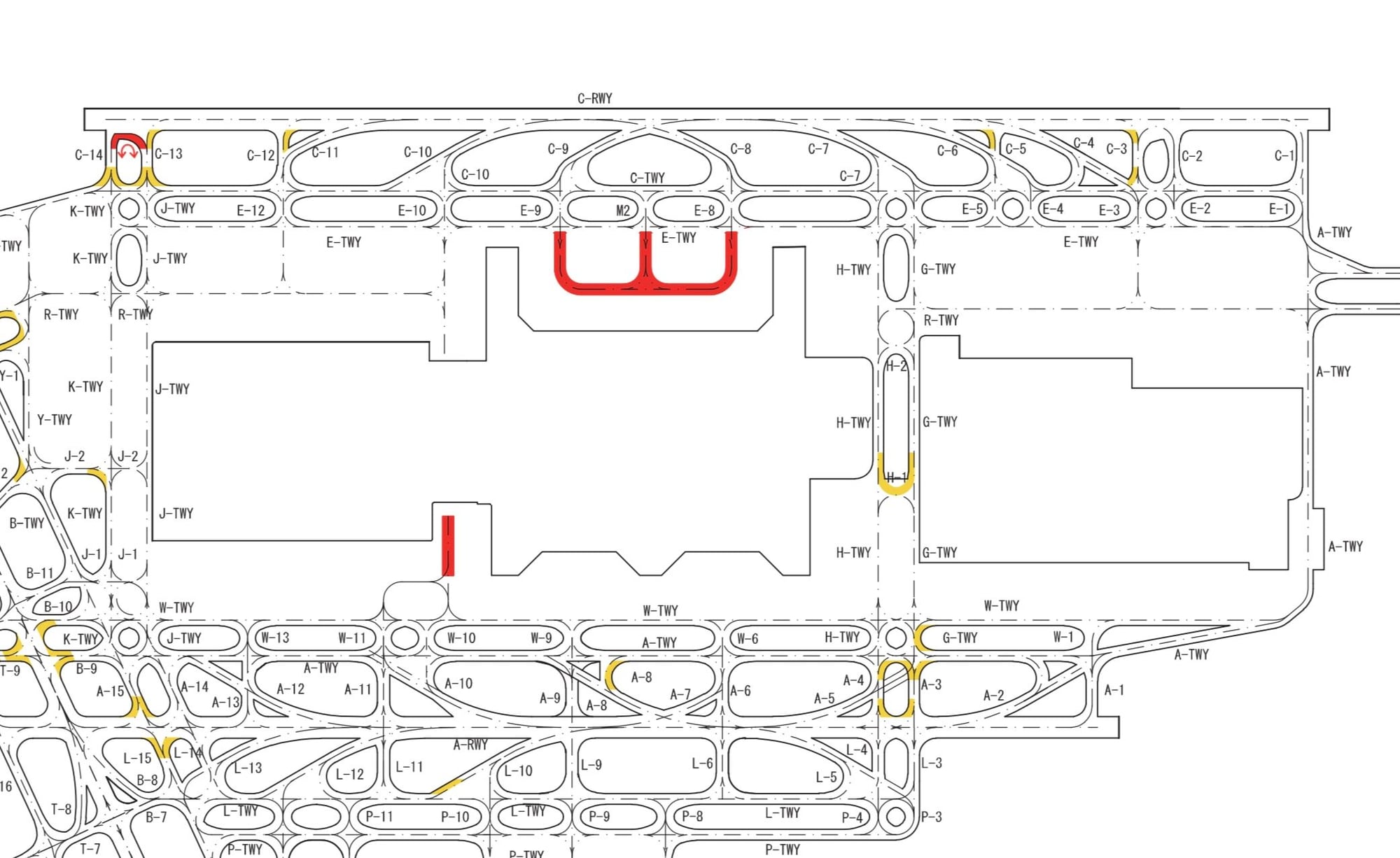
Sequence of events based on ADS-B data from FlyRealTraffic.com / ADS-B Exchange data.
Times in UTC.
GS = GNSS derived ground speed
RSSI = received signal strength. Values > -20 dBFS are strong and reliable transmissions.
Baro altitudes are uncorrected (reference to 1013.2 hPa)
MCP alt sel: The altitude selected on the mode control panel
VS = baro derived vertical speed
QNH at time of incident: 1016.4 hPa at 8C temperature. You should therefore add 96ft to the reported barometric altitudes to obtain corrected altitudes.
Time: 08:47:18
Lat/Lon: 35.541982 139.803538
GS: 124 kts
Baro alt: 0 ft (96ft corrected)
MCP alt sel: 3008 ft
VS: -576 fpm
RSSI: -9 dBFS
Comment:
This is the last position data received. This position is 64m prior to the piano keys on RWY 34R and 2m right of centerline.
There are no ADS-B messages received over the next 4 seconds. At 124 kts that puts the aircraft 252m further down the runway, or just past the first set of touchdown indicators.
This indicates that something disabled the position data in the ADS-B source in those 4 seconds.
The collision therefore likely occurred at the C2/C3 intersection position along RWY 34R.
Time: 08:47:26
Lat/Lon: No data
GS: No data
Baro alt: -100ft (4ft/on ground corrected)
MCP alt sel: No data
RSSI: -7 dBFS
VS: No data
Comment:
This is the next ADS-B message that was received from the aircraft. Still with good signal strength, but now missing a host of data likely due to disabled sensor inputs.
Time: 08:47:28
Lat/Lon: No data
GS: No data
Baro alt: -175ft
MCP alt sel: No data
RSSI: -7 dBFS
VS: No data
Comment:
Only baro altitude and RSSI updates from this point forward. Baro alt fluctuating between -50 to -75 ft with RSSIs between -4 and -13, so still good signal.
The last message received is at 08:48:04.
As an ATCO I am surprised that Haneda does not have any form of RIMCAS (Runway Incursion Monitoring and Collision Avoidance System) to alert controllers of hazardous conditions. At least it seems so according to this document describing Hanedas Runway safety Program
ICAO presentation
ICAO presentation
I gave it a bit more fuzziness, red lines mark roughly the collision zone.
Watching the video on Post #9 it seems that A350 was at landing roll at the moment prior to impact.
Carefully watching it on slow motion on youtube, there is a stationary probe light blinking at least two times (around sec 4 and sec 5 of the video), visible just above the tail of the plane with Star Wars livery. (Crop from screenshot marked which looks like the probe light below.)
Looking at this, it appears that the Dash 8 was stationary inside the runway and was hit by A350 during the landing roll.
Video link: https://www.youtube.com/watch?v=Oy4RIvRcwUo&t=5s
In fact this appears as an Anti Collision Light, and there was no motion.
It's impossible to see the orientation of the Coast Guard Plane.
It's impossible for me to see the nose up angle of the A350 right before impact.
We can assume the impact speed was not too far from landing speed, so like in the 120KN region